Find Your Daily Voice
Weather
Follow
News
Schools
Business
Obituaries
Police & Fire
Weather
Neighbors
Lifestyle
Politics
Sports
Events
Traffic
Legal
Real Estate
Tags
Jobs
Shop
Support Us
Weather
Follow
Find Your Daily Voice
News
Schools
Business
Obituaries
Police & Fire
Weather
Neighbors
Lifestyle
Politics
Sports
Events
Traffic
Legal
Real Estate
Tags
Jobs
Shop
Support Us
Home
About us
All sites
Advertise with us
Contact us
Terms of use
Privacy policy
Code of ethics
Site Map
© 2024 Cantata Media
Warren Hunterdon
Weather
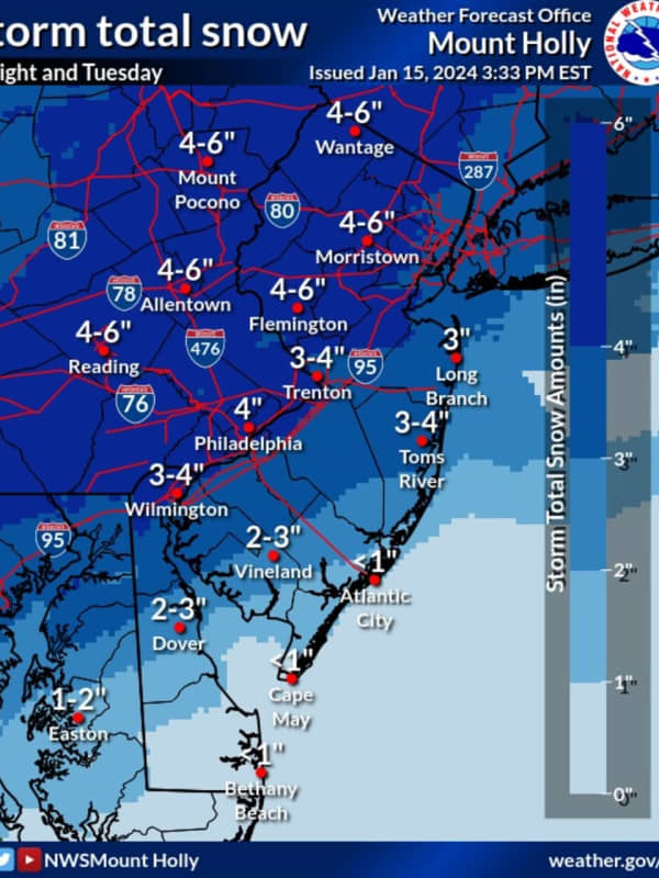
Six Inches Of Snow Could Slam Parts Of NJ, PA: Latest Forecast, Timing Updates
Newly-released forecast maps from the National Weather Service show up to six inches of snow could fall across eastern Pennsylvania and much of New Jersey. Accumulating snowfall will begin Monday, night Jan. 15, mainly after 7 p.m., and carry into Tuesday morning, Jan. 16, impacting the morning commute as it changes over to a wintry mix, the NWS said in its latest briefing. ALSO SEE: North Jersey School Delays For Tuesday, Jan. 16 Between 4 and 6 inches of snow was being forecast for most of North Jersey (including Morris, Sussex, pars of Bergen/Essex/Hudson, Warren, and Hunterdon Counties…
Baltimore
Weather
Sunday Snow Squalls Possible In Parts Of DMV Region, Forecasters Caution
Another storm may bring upwards of an inch of snow to parts of Maryland, Virginia, and DC on Sunday, according to forecasters. While the DMV region won't face the same perils that forced the NFL to postpone the Buffalo Bills playoff game in upstate New York, some parts of the area may see a wintry mix on Jan. 14 as they celebrate the holiday weekend. Temperatures began cooling down on Saturday, with a cold front heading in that could bring whipping winds, some snow showers, and other inclement weather, officials say. Behind a cold front, temperatures will cool off through the day. This …
Hudson
Weather
Snow Squalls Possible Sunday, Fierce Winds Knock Power To Hundreds Of NJ Residents
Quick and intense bursts of snow are possible on Sunday, Jan. 14 across New Jersey, not great news for hundreds of residents still in the dark or dealing with flooding from the latest storms. Parts of Morris and Hunterdon counties are at greatest risk of snow squalls on Sunday, the National Weather Service says. Wind gusts between 40 and 50 mph were possible. ⚠️❄️🌬️ There is potential for snow squalls from Sunday morning into the early afternoon. Remember, there is no safe... Posted by US National Weather Service Philadelphia/Mount Holly on Saturday, January 13, 2024 In Morris Coun…
Arlington
Weather
Possibility Of Snow, Ice Storm For Northeast Next Week Hinges On One Factor: AccuWeather
A winter storm could hit the Northeast next week, but it depends on one factor, forecasters say. A dip in the jet stream. “Should a large dip develop in the jet stream, then a major winter storm will climb the Atlantic coast from Monday night to Tuesday night,” AccuWeather Senior Meteorologist Bob Smerbeck explained. “However, should only a shallow dip in the jet stream develop, the storm would be more likely to escape out to sea, off the southern Atlantic coast by midweek.” Weather maps show a dusting of between one and three inches, should the snow make its way up to New Jersey, eastern…
Arlington
Weather
'Arctic Blast:' Snow, Ice To Threaten Northeast After Windy, Rainy Start To Weekend
Forecasters are tracking two more storms in the coming days: One bringing heavy rain and wind, the other snow and ice to the Northeast. Thursday, Jan. 11 will be partly sunny with a high near 45 while Friday, Jan. 12 will be the same, before rain begins in the evening, the National Weather Service says. The heaviest rain will fall at night and could result in major flooding adding to the damage for the mid-week storm. Quieter conditions are expected today before the next system arrives Friday afternoon into the weekend. Expect another... Posted by US National Weather Service Bal…
Bucks
Weather
Storm Downs Trees, Closes Roads Across Bucks County
Authorities advise residents to adjust their travel routes after heavy rains flooded parts of greater Philadelphia Tuesday night and into Wednesday morning, Jan. 9 and 10. Flood and coastal flood warnings remain in effect Wednesday for Philadelphia and parts of Bucks, Chester, Delaware, Montgomery, Lehigh, and Northampton counties, according to meteorologists at the National Weather Service. Drivers should take care to avoid flooded roadways and should never drive into pooled water, authorities note. Here is a rolling, inexhaustive list of the most recent travel advisorie…
Union
Weather
Falling Tree Misses Officer, Major Roadways Flooded: North Jersey Storm Damage Update
North Jersey residents are feeling the impact of this week's storm with thousands still without power and schools closed or delayed. In Bergen County, houses were hit on East Midland Avenue in Paramus and on Sunset Avenue in Englewood. A Mahwah police officer also escaped serious injury when a falling tree struck his cruiser. Route 17 was closed in both directions at various times in multiple spots, including in Hasbrouck Heights around 9:30 p.m., in East Rutherford just before midnight and in Rochelle Park about an hour later. A stretch of Route 46 in Lodi also was under water, as we…
Essex NJ
Weather
Another Storm Nears: Weather Service Warns Of Event Causing More Flooding In NJ, PA
Yet another storm system is working its way toward the region, the National Weather Service warns. Northern New Jersey and Southeast Pennsylvania will remain in a flood stage through the end of the week, when the second storm is set to arrive, the NWS said. That storm will begin Friday evening, Jan. 12, with rainfall continuing overnight into Saturday, Jan. 13, the weather service said. That storm will also be accompanied by new flooding and damaging winds. While recovery is underway from the storm that affected our region last night, another storm is gearing up to affect our... Posted…
Bergenfield
Weather
Thousands Without Power As Storm Intensifies In NJ
Thousands of New Jersey residents were without power as of Tuesday evening, Jan. 9, as the storm intensified. A State of Emergency ordered by Gov. Phil Murphy went into effect at 5 p.m., with state and local officials urging residents to stay off the roads. As of 7:25 p.m., more than 2,000 residents in Hunterdon County were in the dark, according to JCP&L, including 123 in Delaware; 729 in Lambertville City; 733 in Raritan; 437 in West Amwell, and more. In Morris County, 3,360 JCP&L customers were without power. Those are residents of Mount Olive where 2,449 people w…
Ramapo
Weather
'Avoid Unnecessary Travel': Rockland County Issues Severe Weather Alert
A Hudson Valley county has issued a severe weather alert as a major storm system approaches the area. Rockland County government officials stated on Tuesday, Jan. 9 the system is expected to bring flooding rainfall, strong to damaging winds, moderate to locally major coastal flooding, and major shoreline impacts starting 6 p.m. Tuesday into 6 a.m. Wednesday (the most severe hitting between 10 p.m. and 1 a.m.). According to the National Weather Service, the storm may bring 4 plus inches of rain, widespread moderate to major river flooding threats, and maximum wind gusts of 50 to 60 mph…
Hudson
Weather
State Of Emergency: 65 MPH Winds, Flash Flooding Expected In Severe Storm Headed To New Jersey
Gov. Phil Murphy declared a State of Emergency as all of New Jersey was under multiple weather alerts and advisories on Tuesday, Jan. 9, ahead of a storm expected to pound the region with heavy rain and gusty winds. Between 1 and 3 inches of rain is expected across the state with up to 65 mph winds that could cause power outages and uprooted trees, according to the National Weather Service. ⚠️ State of Emergency effective at 5:00 p.m. on Tuesday, January 9 in anticipation of severe storms causing hazardous weather conditions including heavy rain 🌧️ , high winds 💨, and flash flooding 🌊. —…
Putnam
Weather
New Upcoming Storm Could Topple Trees, Cause Power Outages Across Region, Officials Warn
Now’s the time to charge those phones and find those flashlights. Central Hudson Gas & Electric is urging customers to prepare for possible power outages ahead of a new storm system expected to bring drenching rain and damaging winds to the region. The storm, which is being labeled as a "multi-hazard event" by the National Weather Service, is expected to arrive late Tuesday afternoon, Jan. 9, and increase in intensity Tuesday night into Wednesday morning, Jan. 10. Forecasters warned that heavy rain could bring between 2 and 4 inches of rainfall to some areas along with potentially…
1
2
3
4
5
6
7
8
9
10
Archive